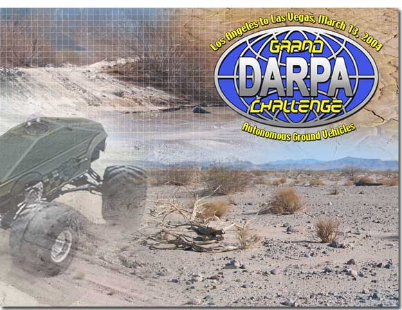
DARPA intends to conduct a challenge of autonomous ground vehicles
through a course
between Los Angeles and Las Vegas (225 to 250 miles) in the
fastest time and in less than 10 hours in March of 2004. A cash
award of $1 million will be granted to the team that fields the
first vehicle to complete the designated route within a specified
time limit. The purpose of the challenge is to leverage American
ingenuity to accelerate the development of autonomous vehicle
technologies that can be applied to military requirements.
Only publicly available signals (e.g., GPS) may be used for
navigation. Otherwise, the vehicle must be fully autonomous,
receiving no other signals for navigation, path planning, obstacle
avoidance, and terrain differentiation. Many of the details of the
event are still being developed. Click here
for more information.
The
attributes of the race can be summarized with the following
points:
•Totally
autonomous vehicle
•DARPA
following (helicopters, etc.) with “big red button” (to stop
vehicle remotely in case of safety concerns.)
•About
250 miles on and off-road. (On road being only about ten percent.)
•About
10 hrs (maximum)
•1000
way-pts to be given 2 hrs before race
•$1,000,000
prize
•400
participants at announcement meeting in LA. 27 teams registered as
of this writing. About a dozen expected to pass DARPA’s safety
and feasibility review.
•A
lot of PR! Various newspapers have already reported on the race.
Different TV programs already filming developments.
The
off-road locations and speed requirements (about 25 mph average
for 10 hours) are presently beyond any state-of-the-art
demonstration we have heard of. The locations between LA and Las
Vegas provide particular problems (see examples on next page).
This is a true challenge!
| Grand
Challenge Schedule: |
| Feb
22, 2003 |
Grand
Challenge Conference |
| Apr
01, 2003 |
Application
Period Opens |
| Oct
14, 2003 |
Application
Period Closes |
| Mar
11, 2004 |
DARPATech
Ceremonial Start |
| Mar
12, 2004 |
Qualification
Inspection & Demonstration |
| Mar
13, 2004 |
Grand
Challenge Main Event |
Background
and Experience of TerraMax Team:
OSU subgroup
The
Ohio State University has a long history in the field of
autonomous vehicle research and development.
A number of early developments in automotive automation
were carried out under the direction of Professor Robert Fenton in
the mid 1970s, including vehicle following using a take-up reel to
simulate an unavailable distance sensor and steering control using
“leaky-coax” cables embedded into the road.
More recently, OSU has participated actively in this area
under the direction of Professor Umit Ozguner and his team. This
research has involved vehicle steering and speed control, sensor
development, sensor fusion, GPS and INS sensing and navigation
technologies, mapping technologies, and wireless communications.
For
four years we fielded a student projects team that competed in the
International Unmanned Ground Vehicle Competition, a competition
that we won in 1996 using a golf-cart based platform equipped with
steer and throttle by wire actuation, an OSU developed image
processing system for lane tracking, and ultrasonic rangefinders
for obstacle avoidance.
Based
on previous work instrumenting and actuating passenger vehicles,
we were invited to participate in the 1997 NAHSC Automated Highway
Systems Demonstration on I-15 in San Diego, CA.
For that event, we developed three fully autonomous
vehicles capable of lateral and longitudinal control at highway
speeds. The platforms
were Honda Accord automobiles, modified by Honda to provide drive
by wire electronic steering and throttle and brake by wire
acceleration control to our specifications. (See below.)
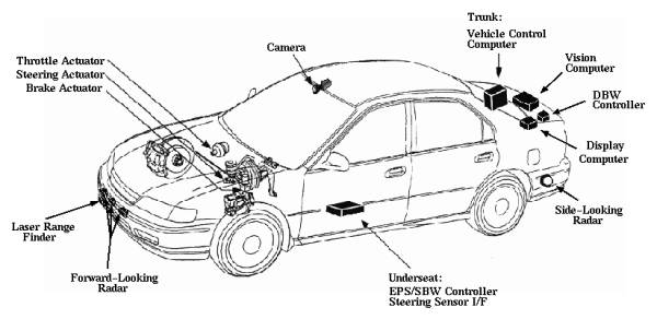
The
vehicles were outfitted with a number of sensors, included an OSU
developed image processing system for lane tracking and an OSU
developed radar system that provided both radar-reflective stripe
tracking for lateral position sensing and forward target detection
for vehicle following and obstacle detection.
In addition, the vehicles were equipped with a prototype
scanning laser rangefinders for vehicle following and forward
obstacle detection, and side looking short distance microwave
proximity detectors for safety during lane change and vehicle
passing maneuvers. All critical sensing tasks were accomplished
using multiple cooperating technologies and sensor modalities to
provide redundancy. At
that time, the control was implemented on dSpace embedded control
computers and an OSU developed software kernel.
Since
that time, we have re-implemented the vehicle control and sensor
management software on an Intel-based industrial single board
computer using QNX, a real time multitasking operating system that
also provides support for GUI development.
We have also implemented a map based vehicle navigation
control system (including both lateral guidance and desired speed
control) using positioning feedback from the fusion of
differential GPS and INS measurements.
We have continued to improve our image-based lane tracking
algorithms, and we have implemented a vehicle following
“electronic tow-bar” control system in which lateral and
longitudinal control are based on tracking a visual tag affixed to
a lead vehicle. Much
of this was demonstrated at the 1999 ITS America AVCSS
Demonstration.
CAPABILITIES
Our
research group has experience designing low-level control
strategies for lateral and longitudinal control.
We have experience implementing or using a number of
sensing technologies, and we understand the issues in the
processing and extraction of data for control purposes from raw
sensor data. We also
have experience in data fusion from multiple sensors, a technology
that, we feel, is critical to successful, reliable autonomous
vehicle operation.
We
also have access to and experience with GIS mapping data and
technologies. For
example, we have developed the hardware and software for GPS based
tracking of transit vehicles and the real-time estimation and
display of vehicle arrival time, which has been implemented both
on the OSU campus and the Central Ohio Transit Authority.
Moreover,
our experiences in conducting previous public demonstrations have
given us a great deal of insight into the administrative and legal
aspects of these activities, and into the issues and requirements
concerning safety, fault tolerance and failure modes, and the
reliability of components.
Finally,
we also have an active relationship with the Transportation
Research Center in East Liberty, OH.
This facility provides on and off road testing capabilities
that could be utilized in this project.
Parma
(Italy) subgroup
The "Artificial Vision
and Intelligent Systems Lab" of the Dip.di Ingegneria
dell'Informazione, Universita` di Parma, Italy, is active in the
field of intelligent vehicles and particularly on the development
of artificial vision systems for advance vehicle safety. Since the
late 80's it has been involved in many projects with automotive
industries and research centers. One of the most relevant results
is the 'MilleMiglia in Automatico' tour, a 2000+ km test drive of
the ARGO autonomous vehicle (totally developed in the Lab) on
italian highways in normal traffic and weather conditions; during
this test (June 1998) the ARGO vehicle drove for almost 95% of the
distance in automatic mode. Currently the Lab is involved in
projects related to the use of daytime and infrared vision for
human shape localization and pedestrian detection, as well as
obstacle, lane, and vehicle detection.
ARGO Project website:
www.argo.ce.unipr.it
Director's website:
www.ce.unipr.it/broggi
Lab website:
vislab.ce.unipr.it |